Mont Pancherot, from Les Perrères


Edited by:
Massimo Martini
Updated at: 13/07/2026
Access
Leave the motorway junction at Châtillon-Saint-Vincent. Turn left and continue for about 300 metres to the roundabout. Take the third exit onto Via Émile Chanoux and follow it for about 600 metres, passing through the historic centre of Châtillon. Turn slightly right onto Via Menabreaz and continue for 450 metres to the roundabout with the Matterhorn monument in the centre. Take the second exit and enter the Regional Road in the direction of Valtournenche. Continue on for about 26.7 km, passing through the municipalities of Antey-Saint-André and Valtournenche. Pass the Goffres de Bousserailles and negotiate a few hairpin bends followed by a short section through a tunnel. At the exit, reach the locality of Les Perrères: turn left and descend to the large parking area 🅿️ where you can leave your car free of charge.
The starting point of the itinerary is served by public transport. To consult the timetable, visit aosta.arriva.it
Distance and travel time
🕒 Travel time: 37 minutes
📏 Distance: 25 km
GPS navigation
📍 How to get there with Google Maps
📍 How to get there with Apple Maps
ℹ️ Important note
The information provided was verified on the date of the survey of the route. Before departure, it is advisable to check for any changes to the route. For up-to-date and detailed directions, we recommend the use of Google Maps or Apple Maps.
Introduction
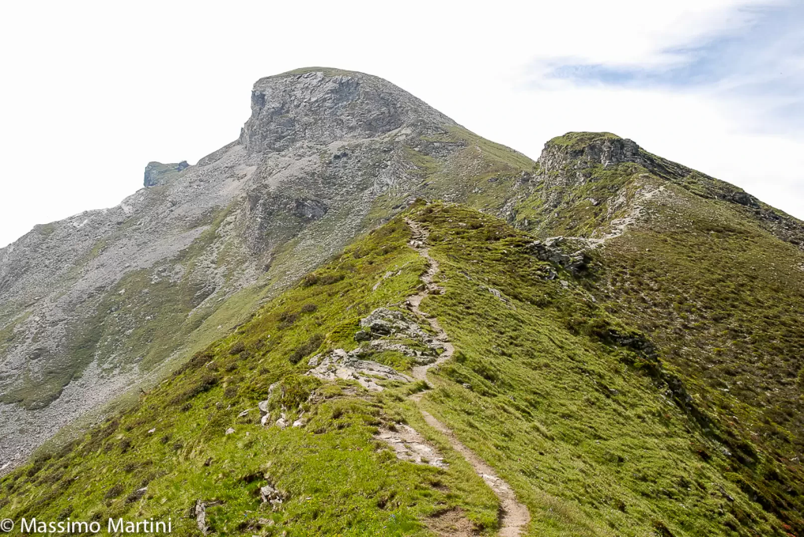
On the orographic right-hand side of the Marmore torrent, an itinerary develops that joins Valtournenche with the Cignana valley via the Finestra of the same name. The ascent, at first through larch woods and ancient alpine pastures, gradually opens up to sweeping views, until it leads to Mont Pancherot. From this grassy peak, which acts as a natural watershed, the view embraces two valleys and finds its focal point in the Matterhorn, emerging in all its grandeur.
The route does not present any particular technical difficulties, except for a few short, more exposed passages on the final ridge, and should only be undertaken in good weather: the terrain can be slippery in some sections. The reward, for those who reach the summit, is the possibility of observing from a privileged position the geometries of the lateral valleys and the great peaks that dominate them.
Description
0h00' 0.00km From the car park, head north along the dirt road that initially runs alongside the 'Perrères' picnic area, until you reach a signpost located near a stream.
0h03' 0.17km Continue along the dirt road, ignoring the path that branches off to the right, and cross the bridge over the Marmore stream. After the bridge, turn left and follow the flat road until you reach a ford, which can be bypassed by means of a wooden footbridge. A little further on, you will come to a new fork with a marker post.
0h10' 0.56km Turn right and ascend the path, which is characterised by a rather steep climb. Cross a strip of larch woodland (Larix decidua) and take the farm track again, which must be followed until reaching the Grillon alpine pasture (1,945 m) 💧. In front of the alpine pasture is a signpost and the start of the path. Continue through the forest, crossing several clearings and skirting a waterhole. With a constant gradient, the trail climbs the slope, alternating between short turns and long, straight stretches, until it leaves the forest and crosses the sparse pastureland before the ruin of Tza Grillon (2,089m). Here the path turns right and, a little further on, re-enters the wood at a gentler gradient, until it reaches a fork signposted.
1h15' 2.62km Turn left and resume the diagonal ascent halfway up the hillside. The path comes out of the forest and increases in gradient until it reaches a panoramic knoll from which, if you turn around, you can admire an iconic view of the Matterhorn. From here, the trail continues at a gentler gradient until it comes into view of the "window" and reaches the barely visible junction of trail coming from Crépin.
1h15' 4.02km Continue straight on in a south-westerly direction until reaching the wide inlet of the Finestra di Cignana (2.445m).
2h15' 4.26km
From the pass, turn left following a path that climbs the grassy ridge of the northern slope of Mont Pancherot. After a traverse under a rocky ridge, the path climbs again to a first altitude (2,623m) and then, beyond a small col, reaches the main summit (2,614m), topped by a cross 2h45' 5.23km .
The return journey takes place along the same route as the outward journey: take the ridge trail again as far as the Finestra di Cignana, then descend to the Tza Grillon, the Grillon Alp and finally to the dirt road that leads to the car park at Les Perrères (1,837m) 1h45' 5.23km .
Points of Interest
Collections
Photo gallery
Comments (0)
Sign in to leave a comment