Lake Ritorto, from Campo Carlo Magno


Edited by:
Androcolo
Updated at: 10/05/2026
Access
To get to Pinzolo follow the directions below.
By Car
A4 Milano (Km 220):
Exit Brescia Est -Lago d'Idro-Tione-Pinzolo-Madonna di Campiglio
A22 Modena-Brenner:
Exit Rovereto Sud-Mori-Arco-Sarche-Tione-Pinzolo-Madonna di Campiglio (Km 92)
Exit TRENTO CENTRO-Sarche-Tione-Pinzolo-Madonna di Campiglio (Km 73)
Exit San Michele all'Adige- Mezzolombardo-Cles-Dimaro-Madonna di Campiglio-Pinzolo (Km 78)
Bus
From Trento:
Trentino Trasporti - Atesina
From Milan-Brescia:
Autostradale Viaggi
Società Italiana Autoservizi
From Toscana-Emila:
Lorenzini Tel. 0187.66804-66805
From Liguria-Lombardy:
Stat Turismo
Introduction
This hike takes us to a mountain lake from which it is possible to see the whole of the Madonna di Campiglio plain.
This is a very interesting hike.Description
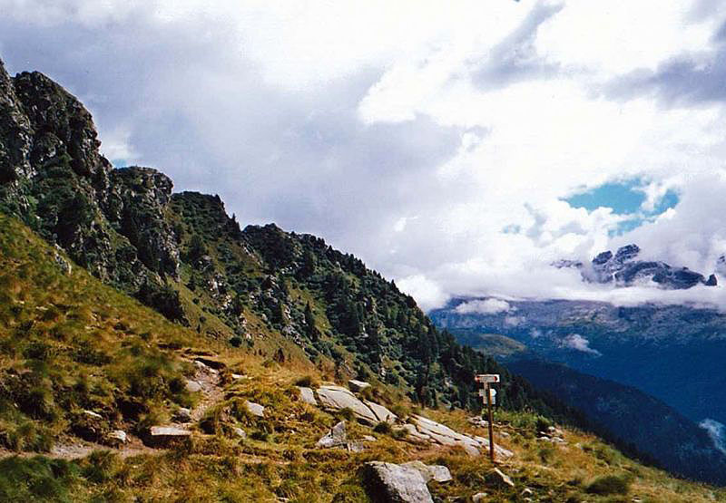
We take the car in the direction of Madonna di Campiglio, and once near the tunnel follow the signs for Campo Carlo Magno. At the exit of the tunnel, having passed the viaduct from which it is possible to see the Pradalago cable car, we take the road on the left which heads towards Piana di Nambino and continue along the road past Malga Patascoss until we reach Malga Ritorto. On arrival, a square in front of the hut of the same name awaits us, where we can leave the car and begin the approach to the path, walking along a dirt road to the slopes of the forest. From here, the path enters winding and bristling curves to climb in a short time, so to speak, up to the slopes of the ridge where the lake is located, which a legend says is haunted by a ravenous dragon.
We begin the ascent to our destination along the path that winds among the rocks, which in addition to the stones, presents the difficulty of avoiding the cows' mouths that have passed. Certainly these Rendene cows are really mountainous, untangling themselves on unthinkable paths to reach the alpine pastures. After almost 45 minutes of ascent, we arrive at the alpine lake. The landscape that presents itself to us is stupendous, the lake opens up into a basin framed by high, rocky peaks, and on one side we can admire the valley of Madonna di Campiglio. It is also possible to get to the lake by another route from the arrival point of the 5 Laghi cable car, (see map whose number is always [232]), which is certainly more convenient as all the difference in altitude is done by cable car.
We stop to rest and refresh ourselves for an hour or so, not because we want to leave immediately but the usual clouds are lurking and this time they even indulge in letting a few drops of rain fall.
For the return we take another path [237] which from the first few metres is easier than the one we took to go up. It is in fact still narrow and rocky but less steep, in fact it winds along the side of the mountain until we reach a fork in the road. Here we take the path to the left that leads into a plain with low vegetation until we enter the forest.
The path is much longer than the one we took on the way up, but certainly less demanding. After about an hour and twenty minutes, the path comes out behind the Rifugio Malga Ritorto. We decide to go in and as soon as we cross the threshold we find ourselves in front of the typical mountain hut with its classic fireplace and stove to warm the cold-hearted patrons, and the benches and tables in rigorous alpine style, so we are tempted to have a good coffee for me and a barley coffee for my wife.
Fatigued but satisfied with the excursion, we take the car back to our mountain base.
Bibliographic references
- Brenta Dolomites-Adamello-Presanella Val di Sole, Carta Topografica, foglio 10, 1:50000, Casa Editrice Tabacco, 2006
- Tabacco, Dolomiti di Brenta-Adamello-Presanella-Val di Sole, foglio 10, scala 1:50.000, Udine
AttachmentDimensionsSignposts before the lake © 2008 Maurizio Peroni | 127.22 KB
Signposts at the lake © 2008 Maurizio Peroni | 154.88 KB
The Brenta Dolomites © 2008 Maurizio Peroni | 130.49 KB
Panoramic view © 2008 Maurizio Peroni | 219.77 KB
Riferimenti Bibliografici
- Dolomiti di Brenta Adamello-Presanella Val di Sole, Carta Topografica, foglio 10, 1:50000 - - Casa Editrice Tabacco, 2006, Udine
- Dolomiti di Brenta-Adamello-Presanella-Val di Sole, foglio 10, scala 1:50.000 - - Casa Editrice Tabacco, 2006, Udine
Comments (0)
Sign in to leave a comment