Venice

Edited by:
Massimo Martini
Access
The municipality is accessible by car via the Turin–Trieste motorway, with the exit at Venezia-Mestre for the mainland section and continuing across the Ponte della Libertà to Piazzale Roma for the island historic centre — the only vehicular entry point. From the north, the Belluno–Venice motorway joins the Mestre ring road ( motorway), from where signs direct to Venice centre or the airport. The ordinary road network runs along the Triestina state road, connecting the lagoon territory with the north-eastern hinterland towards Quarto d'Altino, and the Padana Superiore state road heading west. Motor vehicles may not enter the historic centre: the Ponte della Libertà leads exclusively to Piazzale Roma, where parking facilities are located. The main railway stations are Venezia Santa Lucia — the terminus of the rail line within the island historic centre — and Venezia Mestre, both served by Trenitalia (TI) and Italo with high-speed and regional trains from across Italy. The Marco Polo international airport (VCE), located in Tessera, a fraction of the municipality approximately 13 km from the historic centre, is connected by bus to Piazzale Roma and Mestre station via ACTV and ATVO lines, and by water via Alilaguna vaporetto services to the Fondamenta Nove. Public transport across the lagoon territory is operated by ACTV with vaporettos and motor launches; on the mainland by bus lines.
Introduction
Venice lies in the north-eastern Veneto plain, facing the Adriatic gulf of the same name, and extends partly across 118 islands at the centre of the lagoon, and partly on the mainland through the centres of Mestre and Marghera. Capital of the Veneto region and the metropolitan city of the same name, it borders eleven municipalities of the lagoon territory and the Po plain hinterland. The city's history is rooted in the period of the barbarian invasions of the 5th and 6th centuries, when populations from the plain sought refuge on the lagoon islands; from that first settlement, the Republic of Venice gradually developed over the centuries into a maritime and commercial power that for more than a millennium controlled trade between Europe and the Orient. The urban structure of the historic centre — with its canals, calli, campi and sestieri — has no equivalent in the European urban landscape. In 1987, the city and the entire lagoon were declared a UNESCO World Heritage Site, a recognition that certifies their historical and architectural value on a global scale.
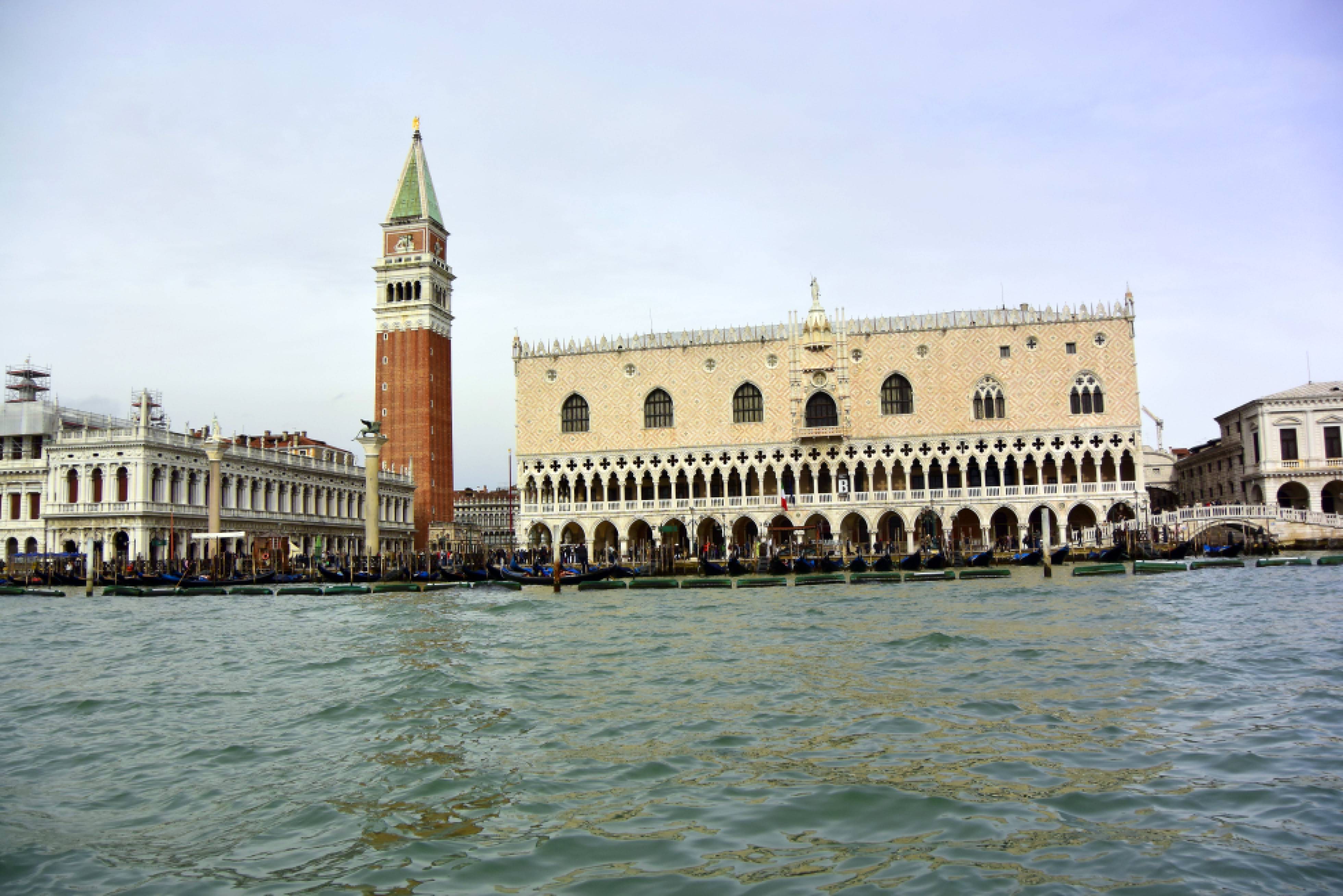
Description
The municipal territory is divided into two geographically distinct parts, separated by the lagoon system. The island zone encompasses the historic centre with its six sestieri — Cannaregio, Castello, Dorsoduro, San Marco, San Polo and Santa Croce — which develop around the double meander of the Grand Canal, traversed by a network of approximately 158 minor canals crossed by over 400 bridges. The island zone also includes the outer lagoon islands: Murano, home to the age-old tradition of blown glass craftsmanship; Burano, known for its bobbin lace production; Torcello, with its early Christian monuments including the Basilica of Santa Maria Assunta; and the Lido and Pellestrina, which form the coastal barriers between the lagoon and the open sea. The mainland, with approximately 130 km² of surface area, is home to more than two-thirds of the resident population, concentrated mainly in Mestre and Marghera, whose development is closely tied to the great industrial expansion of the 20th century and the construction of the commercial port and chemical-industrial complex of Porto Marghera.
The origins of the lagoon city date to the final centuries of antiquity. According to historiographical tradition, the first permanent settlement on the Rialto islands is dated to the 5th century, when populations fled before the invasions of the Huns (452) and the Lombards (568). From the duchy founded by the Byzantines, the Republic of Venice gradually developed, officially active from the year 697 until its fall at the hands of Napoleon Bonaparte in 1797. Over more than eleven centuries, the Serenissima built a system of commercial and colonial dominance that extended from the Levant to the Venetian territories of the mainland, leaving a deep mark on the architecture, art, law and culture of the entire eastern Mediterranean. Between the 10th and 16th centuries, the Republic was among the greatest naval powers in the Mediterranean; the Venice Arsenal, a shipyard complex on the eastern edge of the historic centre, was the largest productive structure in Europe of its time. The city was annexed to the Kingdom of Italy in 1866, following the plebiscite after the Third War of Independence.
The physical structure of the historic centre is the product of a centuries-long process of adaptation to the conditions of the lagoon. Buildings rest on foundations made of wooden piles — traditionally of black alder (Alnus glutinosa) — driven into the muddy bed, a technique that has ensured the stability of constructions over time. The phenomenon of acqua alta — the rise in water level caused by the combination of astronomical tide, sirocco wind and oscillations of the Adriatic water mass — is a recurring seasonal feature, with peaks concentrated between autumn and spring. Since 2003, the MOSE system of mobile floodgates at the lagoon's port inlets has been under construction, entering experimental operation from 2020 with the aim of containing exceptional flooding events.
The architectural heritage of the historic centre is of exceptional density. The Basilica of San Marco, with its golden mosaics covering the ceilings of the five domes, and the Palazzo Ducale, seat of the Serenissima's government for over five centuries, form the monumental heart of the city. The Grand Canal is flanked by Gothic, Renaissance and Baroque palaces including Ca' d'Oro, Ca' Rezzonico and Ca' Pesaro. The Rialto Bridge, the oldest of the four crossings of the Grand Canal, dates from the late 16th century. The church of Santa Maria Gloriosa dei Frari houses the tombs of Titian and Antonio Canova; the Gallerie dell'Accademia holds one of the most significant collections of Venetian painting from the 14th to the 18th century. La Fenice, rebuilt after the fires of 1836 and 1996, is among the most celebrated opera houses in Europe.
In terms of contemporary activity, Venice hosts the Venice International Film Festival — the oldest film festival in the world, founded in 1932 — and the Venice Biennale, which alternates exhibitions of visual arts and architecture every two years. The lagoon territory is crossed by walking and boat itineraries linking the historic centre to the minor islands, with opportunities for naturalistic exploration in the barena wetland areas and the inner lagoon channels.
Information
General Data
Surface area: 418.39 km²
Altitude of the main centre: 2m
Population: 249,490 (as of 01.01.2025, ISTAT)
Name in dialect: Venesia (Venetian)
Name of inhabitants: Venetians
Patron saint: Saint Mark – 25 April
Neighbouring municipalities: Campagna Lupia – Cavallino-Treporti – Chioggia – Jesolo – Marcon – Martellago – Mira – Mogliano Veneto – Quarto d'Altino – Salzano – Spinea
Metropolitan city: Metropolitan City of Venice
Region: Veneto
Country: Italy
Official website: https://www.comune.venezia.it